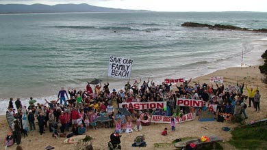
Notting Hill is one of the smaller suburbs of Melbourne situated in the Monash City Council area. The residential part of the suburb is near the Clayton Monash University campus. It is often confused with Clayton.
The suburb includes a distinct residential area of 700 dwellings. This distinct area of housing and streets is encircled or surrounded by major traffic arteries on three sides. The residential estate is bounded by Blackburn Road, Ferntree Gully Road and the Monash Motorway. These are among the largest multi land traffic arteries in Melbourne.
The suburb has only two entry and exit streets and cannot be exited without crossing or entering the six lanes of Blackburn Road or Ferntree Gully Road.
On the other edge of the suburb is an industrial area and the rapidly expanding Monash science park/business park (along Blackburn Road and including the new Australian Synchrotron). This is a major area of expanding employment - the result of planned structural change.
The development of the Notting Hill suburb is also perhaps unique. The residential estate was built in the 1950’s and 1960’s by A V Jennings as the first planned suburb in Melbourne. It was planned in the sense that shops and schools were within walking distance without crossing major roads, and traffic flow was limited.
Unfortunately when finished the “planned” suburb failed to include any parkland or open recreational space for residents.
As the suburb filled up a primary school and a secondary college were built along with a kindergarten/preschool. (Monash Primary School, Monash Secondary College and Westerfield Pre School)
The playgrounds and an oval of these schools became the recreational spaces of residents as well as their children.
In recent years the community has lost its kindergarten/preschool, primary school and secondary school (the primary school in 2004 and the secondary college in 2006). On 7 August the Monash Council agreed to rezone the Monash Primary School and its open space for high-density housing.
The school closures were justified in terms of declining school attendance numbers and an aging population despite vigorous objection from local residents that the demographics in the suburb were changing quickly again to young families. Now as the Government moves to cash in on the land value of the school the Education Department is still attempting to justify its decision by using the same population figures that are a decade old and were disputed even then.
In 2007 residents conducted their own survey of households in Notting Hill and accessed the latest census data. This research demonstrated an increasing number of children of school age in need of a school and a turnover in occupancy in the suburb with more families moving in. An increasing density of residential use was also noted with suburban in fill and unit development.
The result has also been an increase in car travel as children are driven daily to schools several kilometres way.
The Monash Secondary College faces the same fate as the Primary School. It has been declared surplus to requirements and is being allowed to decay into dereliction. This includes a theatre built at the Secondary College by community support and public fund raising. The local cricket club has been banned from using the school oval for the local cricket competition.
The kindergarten (a Monash Council venture) was last used as pre school in May 2007 and is now a Neighbourhood Centre supported by Monash Council.
This has all occurred while:
• Occupancy change and suburban infill has lead to increased population density in Notting Hill and increased number of children of school age.
• Increasing congestion of the highways that grid-in Notting Hill
• Forced increase in car use out of Notting Hill as children are transported out for schooling
• Loss of publicly owned spaces used for recreation by a community with no dedicated parks or recreational areas
• From the edge of the Notting Hill housing area high-density accommodation is encroaching into the suburb. Several hundred units have been built by private developers between the suburban streets and Blackburn Road as part of a speculation into the market for accommodation for overseas tertiary students. This is to be the ultimate fate of the land where the Monash Primary School used to provide its public services.
• Transport and other amenities are to be put under further pressure by a massive increase in employment in the business park area adjoining Notting Hill. Recently Telstra announced it was moving 4000 employees into this area. Until the loss of state government services these employees could have walked from their place of work to a pre-school, a primary school and a secondary college.
It is clear that liveability in Notting Hill is secondary to short-term speculative development.
The disappointing aspect is that the State Government is in no way neutral but a participant and beneficiary of this sale of public amenities.
This loss of public space will never be rectified.

